Luconia Breakers: China’s New “Southernmost Territory” in the South China Sea?
Andrew Chubb, “Luconia Breakers: China’s New ‘Southernmost Territory’ in the South China Sea?” South Sea Conversations, 16 June 2015.
In a vivid illustration of how dynamic the status quo in the South China Sea can be, an apparently new Spratly island, formed by the forces of nature, has become a source of tension between China and Malaysia.
Luconia Breakers (Hempasan Bantin / 琼台礁) is just over 100km north of James Shoal, the shallow patch of ocean that Chinese people are routinely taught is the southernmost point of their country’s “territory,” despite it being several metres underwater.
As this post will show, unlike James Shoal, the territory at Luconia Breakers actually exists above the waterline. This is significant because if the PRC ever needs to clarify the nature of its maritime claims under international law, it could end up adopting the “new” feature as its southernmost territory.
Topping off the intrigue, the train of events leading to the current Sino-Malaysian standoff may well have been set in motion by an adventurous Chinese magazine team.
Here is the part where they “discover” the island at Luconia Breakers… :
In the afternoon the boat heads for another reef, this time in the South Luconia Shoals — Qiongtai Reef [Luconia Breakers]. I imagine it will be another like Nanping Reef [南屏礁], an underwater atoll.
…‘There’s an island ahead,’ says [photographer] Wu Lixin suddenly.
I don’t believe him — we came here to look for China’s southernmost land, but the entire voyage so far has been a disappointment [with no sign of dry land]. But here on the horizon there is a spot of white. Wu runs up the stairs and takes out a telescope.
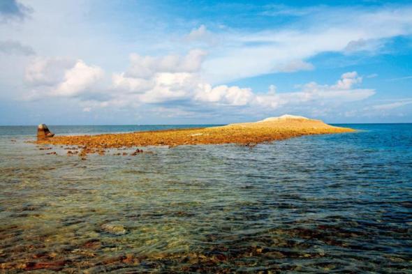
‘It’s really an island,’ he says. The boat heads in the white dot’s direction. So Qiongtai Reef is actually a miniature island above the waterline, surrounded by a reef. Might this be the southernmost above-water Chinese territory we have been searching for? Yes. Looking at the map, it appears so.
The water turns that jade-green hue that indicates it’s getting shallow. The boat stops; it can’t go any further. Looking across the water, the green-coloured area appears to be ring-shaped, meaning this is another coral atoll. The difference is there is a little island in the middle of this one. From a distance it is white. I’m extremely excited, as this beyond our expectations. This kind of formation is called a grey-sand island, formed by storms piling up fragments of dead coral.
…We can only get to the island in a dinghy, which is lowered into the water from the main boat. We get in and set off. At one point we stop for [underwater photographer] Wu Lixin to dive in. Only after noting the GPS coordinates do I let the fat crew member continue to drive us towards the island. As the dinghy accelerates forward, a school of flying fish emerges.
…The next 1-2 kilometres is all underwater gardens. Everything else aside, I think this atoll, this islet, this expanse of coral sea is incomparably valuable, and it’s worth Chinese people proclaiming sovereignty over, and building it into a Chinese Spratly coral national park to be permanently protected. This may well be the Chinese people’s best diving spot, and could become the place where our descendants get to know coral, tropical fish, molluscs, and all kinds of tropical marine life. Can this wish of mine be realized?
The water is getting shallower, and the dinghy is now hitting the bottom. We get out, and the water is only up to our knees. Beneath our feet are fragments of coral skeletons. The islet is in front of our eyes.
We quickly make landfall. All around us are pieces of white coral, which makes a crunching sound with every step. These coral fragments are piled up into a hill about 8 metres high. This is the height now, at 4pm on May 8, 2009, which is low tide, so the island seems particularly large. There is a horizontal line dividing the island into two sections: one dry and white, the other wet and brown. This is the high-tide line, and it shows there is about 3-4 metres’ difference between the water level at the two extremes.
On the island we see traces of humans — a spoon, a bag, and some plastic water bottles dumped by the tide. The most prominent is a large, pyramid-shaped concrete block that appears to be there for political reasons, being in the shape of a sovereignty marker. There is no writing on it, or perhaps the words have been worn away. It would not have been easy to get this concrete tablet here.
The Chinese National Geography team pose on top of the island at Luconia Breakers 琼台礁
According to Shan, when the photograph above was taken, his GPS indicated an elevation of 9 metres above sea level. …
Shan Zhiqiang was at the time Editor-in-Chief of the Chinese National Geography Editorial Department 编辑部主编. He has since been promoted to Executive Managing Editor 执行总编 of the magazine publishing house.
China’s southernmost territory?
Recapping the significance of the voyage at the end of the Chinese National Geography article, Shan emphasized the likelihood that they had discovered China’s southernmost land point:
Most importantly, Qiongtai Reef may be China’s southern extremity — the southernmost point that has dry land. Unless an ice age comes [making] James Shoal protrude above the water…at present, Qiongtai Reef is probably the southern extremity of China’s land 中国陆地的最南端.
In this video, Shan says that after they returned, the team consulted with experts from the State Oceanic Administration (SOA), who confirmed that this was indeed the case. …

