“South China Sea Military Capabilities Series”—Unique, Penetrating Insights from J. Michael Dahm, former Assistant U.S. Naval Attaché in Beijing
J. Michael Dahm, South China Sea Military Capabilities Series: A Survey of Technologies and Capabilities on China’s Military Outposts in the South China Sea (Laurel, MD: The Johns Hopkins University Applied Physics Laboratory, 2020).
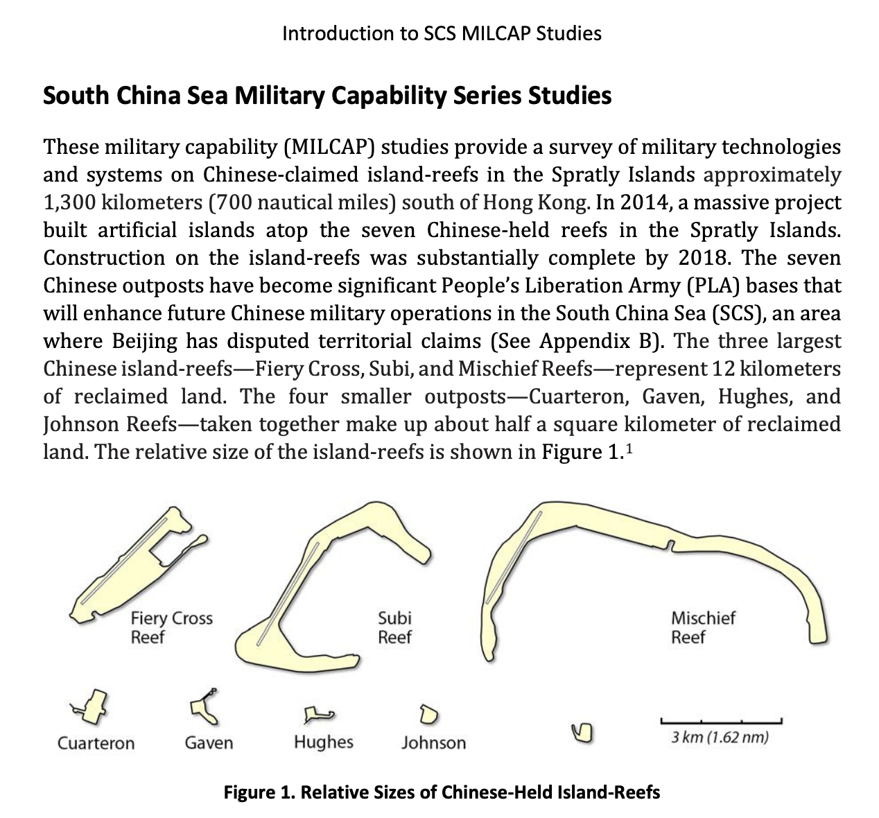
In the information age, the Chinese People’s Liberation Army (PLA) believe that success in combat will be realized by winning a struggle for information superiority in the operational batttlespace. China’s informationized warfare strategy and information-centric operational concepts are central to how the PLA will generate combat power. These South China Sea (SCS) military capability (MILCAP) studies provide a survey of military technologies and systems on Chinese-claimed island-reefs in the disputed Spratly Islands. The relative compactness of China’s SCS outposts makes them an attractive case study of PLA military capabilities. Each island-reef and its associated military base facilities may be captured in a single commercial satellite image. An examination of capabilities on China’s island-reefs reveals the PLA’s informationized warfare strategy and the military’s designs on generating what the Chinese call “information power.” The SCS MILCAP series is organized around different categories of information power capabilities, from reconnaissance to communications to hardened infrastructure. Kinetic effects will remain an important component of PLA operational design. However, any challenger to Chinese military capabilities in the SCS must first account for and target the very core of the PLA’s informationized warfare strategy—its information power.
South China Sea Military Capabilities Series Documents:
- Introduction to South China Sea Military Capability Studies
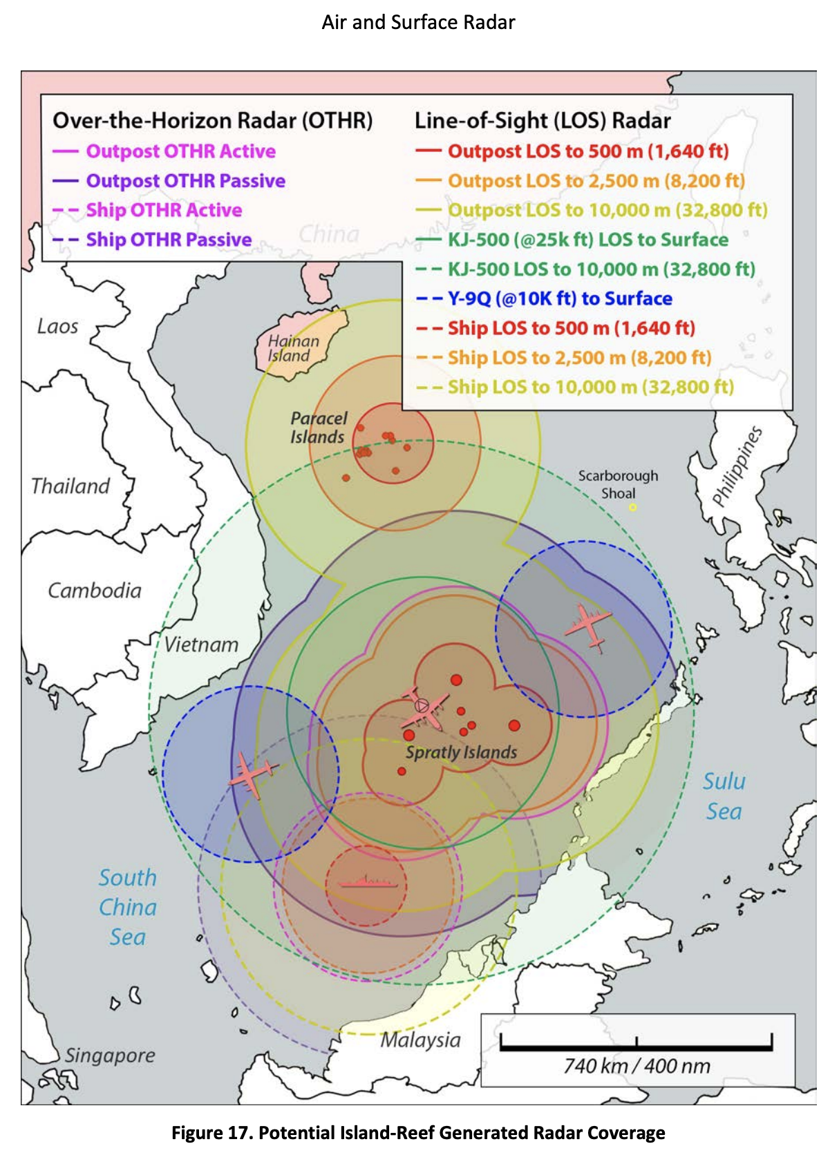
- Air and Surface Radar
- Electronic Warfare and Signals Intelligence
- High-Frequency Communications
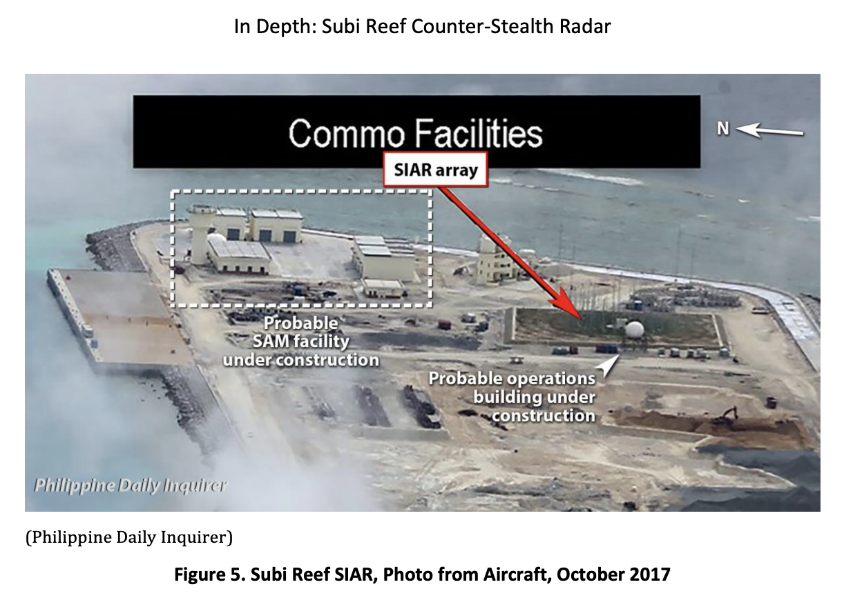
- In Depth: Subi Reef Counter-Stealth Radar
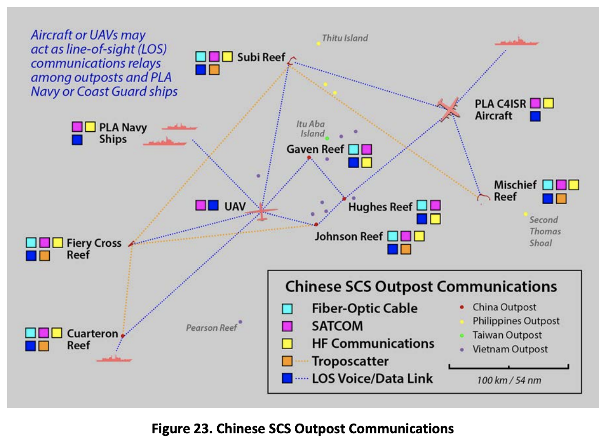
- Inter-Island Communications
- Undersea Fiber-Optic Cable and Satellite Communications
J. Michael Dahm is a senior national security researcher at the Johns Hopkins University Applied Physics Laboratory (JHU/APL) where he focuses on foreign military capabilities, operational concepts, and technologies. Before joining JHU/APL, he served as a U.S. naval intelligence officer for over 25 years, with extensive service across the Asia-Pacific region. His most recent assignments included senior analyst in the U.S. Pacific Command’s China Strategic Focus Group at Camp H. M. Smith, Hawaii; assistant naval attaché at the U.S. Embassy in Beijing, China (2012-15); and senior intelligence officer for China at the Office of Naval Intelligence in Suitland, Maryland.

CONTENT REGARDING MARITIME MILITIA:
“Inter-Island Communications,” in J. Michael Dahm, South China Sea Military Capabilities Series: A Survey of Technologies and Capabilities on China’s Military Outposts in the South China Sea (Laurel, MD: The Johns Hopkins University Applied Physics Laboratory, 2020).
p. 7
4G Cellular Communications
State-owned China Telecom installed 4G cellular communications base stations on the Chinese-held island-reefs beginning in 2015.11 These cellular base stations are purportedly for use by civilians and military personnel stationed on the Chinese island-reefs, as well as by nearby fishermen or transiting ships. Cellular networks are probably also used for military communications, even if the PLA maintains a network independent of the civil network.
***
11 Liu Yuying, “中国电信 4G 信号覆盖南沙七个岛礁” [China Telecom’s 4G Signal Covers Seven Island Reefs in Nansha [Spratly Islands]], 中国新闻网 [China News Network], July 16, 2016, http://www.chinanews.com/gn/2016/07-16/7941155.shtml.
p. 8
Researchers at CETC’s 28th Research Institute (28th RI), which manufactures command information systems for the PLA, 12 indicated that 4G LTE cellular communications have been used to create limited-area, high-speed broadband mobile networks for military units. The researchers recognize network security issues inherent in adapting commercial 4G cellular technology for military use. Still, they propose a variety of applications to improve battlespace situational awareness, command and control, and even positioning and navigation services.13
Assuming that network security issues are addressed, the cellular communications on the SCS island-reefs may provide the PLA with a high-speed wireless network that could service individual troop tasks or provide connectivity for equipment deployed to the island-reefs. Alternatively, the cellular network could serve as backup communication system if underground or overhead communications cables on the island-reefs are damaged or destroyed. The cellular network almost certainly affords civil authorities, including the Chinese paramilitary Maritime Militia forces, voice and high-speed data services when operating in the vicinity of the Chinese outposts.
Fifth-generation (5G) cellular service will significantly improve mobile communication data throughput on the SCS island-reefs with the potential for sophisticated encryption and Internet-of-things (IoT) functionality. In May 2019, China Mobile activated its first 5G cellular base station in the SCS on Fiery Cross Reef. The announcement touted a ten-fold increase in data rates over the outpost’s 4G base station. China Mobile indicated that 5G services would be extended to the other SCS island-reefs but no timeline was provided.14
***
12 The 28th RI is also known as the Nanjing Electronic Engineering Research Institute. It should not be confused with the 14th RI, also located in Nanjing and known as the Nanjing Electronic Technology Research Institute.
13 Luo Mingxin, Chang Junjie, and Zhou Hui, “4G 移动通信技术及其军事应用” [4G Mobile Communication Technology and its Military Application], 指挥信息系统与技术 [Command Information System and Technology] 5, no. 2 (April 2014): 56–60.
14 “中国移动 5G 再次南伸!南沙永暑礁 5G 基站开通” [China Mobile’s 5G Extends South Again, Nansha Yongshu Jiao (Spratly Islands Fiery Cross Reef) 5G Base Station Opened] 人民网讯 [People’s Daily Online], May 24, 2019, https://www.sohu.com/a/316172783_354877.
“Undersea Fiber-Optic Cable and Satellite Communications,” in J. Michael Dahm, South China Sea Military Capabilities Series: A Survey of Technologies and Capabilities on China’s Military Outposts in the South China Sea (Laurel, MD: The Johns Hopkins University Applied Physics Laboratory, 2020).
p. 10
Beidou (北斗) Satellite Navigation Network
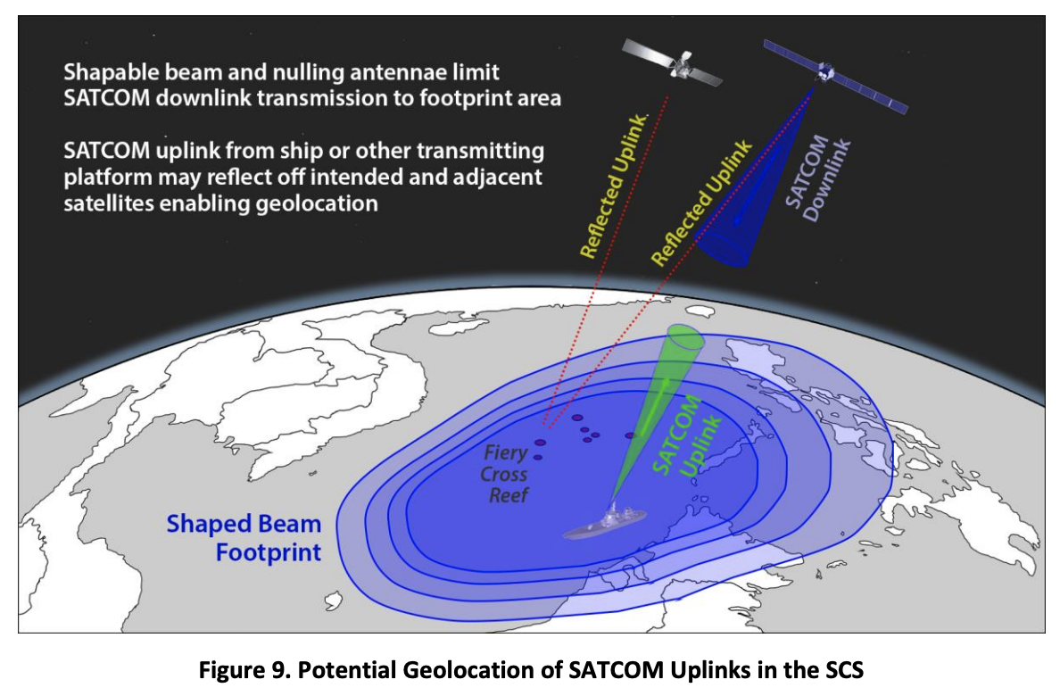
Military or civil–military operations in the SCS may be coordinated through China’s Beidou (北斗) satellite navigation system. Unlike other Western or Russian satellite
p. 11
navigation systems, such as the US Global Positioning System (GPS), Beidou offers an imbedded S-band, two-way short-message service (SMS) that may be especially useful in an expansive maritime environment like the SCS. Chinese shipping and fishing fleets reportedly use Beidou SMS texting extensively. Chinese military newspaper articles noted the importance of the text messaging service in monitoring activities at sea and coordinating with civilian ship formations such as those from China’s paramilitary maritime militia.27 For additional information on Beidou positioning, navigation, and timing (PNT) capabilities, see the SCS MILCAP study, “Hardened Infrastructure, Battlespace Environmental Management, and Counter- Reconnaissance.”
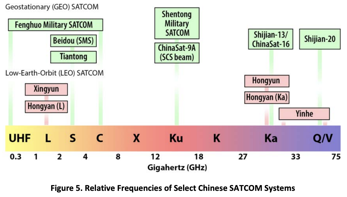
Chinese military SATCOM demonstrates a frequency diversity similar to other PLA communications and information-related capabilities. Figure 5 depicts the relative frequencies used by the different communications satellites outlined in this study. SATCOM systems such as the Fenghuo and Shentong-series satellites are certainly in use in the SCS in 2020. Newer systems, like the Shijian-series or the Xingyun and Hongyun LEO satellites, may be available for use by the mid-2020s. This graphic does not depict specific frequencies nor does it account for other Chinese government- commercial satellites operating in C-, Ka- and Ku-bands that probably augment dedicated PLA SATCOM.
***
27 Guo Bin and Lin Youwei, “有了北斗, 船艇多了双眼睛” [With Beidou, Boats Have More Eyes], 中国军网 [China Military Network], April 11, 2017, http://www.81.cn/gfbmap/content/2017- 04/11/content_174603.htm.
RELATED PUBLICATIONS BY MICHAEL DAHM:
J. Michael Dahm, “Beyond ‘Conventional Wisdom’: Evaluating The PLA’s South China Sea Bases In Operational Context,” War on the Rocks, 17 March 2020.
Imagine entering a dark room. You can neither see nor hear, but your adversary can see and hear everything. Your opponent lives in the room and knows its every contour. For you, there are only a few ways in … or out. You may believe that you have the edge in technology and training. Allies and partners offer their support. But in the confines of the room, you cannot determine where to point your weapons and you are unable to communicate with your friends. In the dark, your foe watches and waits, preparing to pick off your team one-by-one from unexpected directions. If you reveal your position, or call for help, those in the shadows will hear.
This is the nightmare that U.S. military planners face in the South China Sea.
China’s Spratly Island outposts’ offer Beijing decisive information superiority against any challenger in the South China Sea. Their primary purpose is not military power projection and the deployment of weapons, but information power. The Chinese bases’ main contribution is to facilitate substantial command, control, communications, computers, intelligence, surveillance, and reconnaissance capabilities in the South China Sea. International legal opinion notwithstanding, the People’s Liberation Army (PLA) behaves as if the militarized island-reefs are within Chinese territory. The outposts have developed into hardened military bases that have given the Chinese de facto control of what Beijing regards as its waters. Similar to military bases found on the mainland, the South China Sea outposts are integrated into a larger Chinese joint force system-of-systems that supports evolving PLA strategies. … … …
Michael Dahm, “Chinese ‘Ocean E-Stations’ Deployed to the South China Sea,” AMTI Update, Asia Maritime Transparency Initiative, 10 December 2018.
The structure identified on Bombay Reef in AMTI’s November 20, 2018 report, China Quietly Upgrades a Remote Reef, is likely a fixed communication and surveillance platform known as an “Island-Reef Information System.” According to AMTI’s analysis, China had apparently installed the platform on the Paracel Island archipelago in the South China Sea sometime before July 7, 2018. An “Island Reef Information System” is an “Ocean E-Station,” a component of a larger “Blue Ocean Information Network” that is being developed by the Chinese government to aid in the exploration, exploitation and control of the maritime environment using information technology.
The state-owned China Electronics Technology Group Corporation (CETC) has developed at least two types of “Ocean E-Stations” (海洋 E 站) that are meant to expand the information collection and communication networks created by China’s South China Sea islands and outposts. CETC has promoted the information platforms on social media since last year. The “Island-Reef Information System” (岛礁信息系统), almost certainly the platform imaged on Bombay Reef, is an unmanned, fixed platform designed for installation on an uninhabited reef in up to 32 feet (10 meters) of water. The “Anchored Floating Platform Information System” (锚泊浮台信息系统) is an Ocean E-Station with virtually identical capabilities that may be deployed in water depths between 200 and 13,000 feet (60 and 4000 meters). The Bombay Reef fixed platform appears to be the first Chinese Ocean E-Station identified by Western media operating in the South China Sea. However, as many as five floating platforms have already been deployed in the South China Sea, according to CETC representatives and Chinese Maritime Safety Administration (MSA) notices.
Trade brochures provided by CETC indicate the purpose of the Ocean E-Station platforms is to conduct electronic surveillance, provide maritime communications, aid in search-and-rescue, and monitor the ocean environment. The platforms may also act as information nodes to provide power and connectivity for a variety of on-board or off-board systems including, for example, an undersea environmental monitoring system, hydroacoustic array, or other subsurface system.
The fixed platform dimensions are 85 feet long by 56 feet wide and 32 feet tall (26 meters long by 17 meters wide and 10 meters tall). The cylindrical floating platform is 60 feet in diameter and 112 feet tall (18 meters in diameter and 34 meters tall). Half of the floating platform is submerged to provide stability. The platform’s solar panels and wind turbines generate electricity and, using battery storage, provide a consistent 4 kilowatts (kW) of electricity (up to 10kW peak power) in various DC and AC voltages to power on-board and off-board systems. The large radome houses a satellite dish, radar and other antennae. Antennas, sensors, and cameras also occupy the platform perimeter. CETC estimates the lifespan of the systems is 20 years with routine maintenance.
Communication capabilities for both platforms include Ku- or Ka-band satellite communications (SATCOM) (greater than 2 Megabits per second (Mbps)), S-Band SATCOM, and shortwave radio. The platforms can also relay calls from 4G LTE cellular service and provide a link to a text messaging service available through China’s Beidou satellite navigation system. The fixed platforms also offer troposcatter communications (greater than 8 Mbps) if located within 200 miles of another troposcatter station.
Surveillance systems include an air- and surface-search radar as well as an electronic signal monitoring suite. CETC brochures indicate the system can detect frequencies between 1 Gigahertz (GHz) and 18 GHz, and can attain bearings on frequencies between 30 Megahertz (MHz) and 3 GHz. According to information from a CETC subsidiary that makes electronic components for the platforms, the CETC surveillance system can also detect distributed frequency-hopping signals, specifically the U.S. military data link JTIDS (Link-16). The platforms can monitor Automatic Identification System (AIS) and Automatic Dependent Surveillance Broadcast (ADS-B) transmitted by ships and aircraft respectively. Cameras covering both the visible and infrared spectrum provide photoelectric surveillance to the horizon. A number of sensors are also arrayed above and below the water for hydrological and meteorological monitoring.
… … …


")
")


")
")


 Development: Drivers, Trajectories and Strategic Implications")